
Havana Harbour Charrette, Cuba Building, Project, Photo, News, Design, Property
Havana Harbour – Charrette, Cuba : Waterfront Architecture
Waterfront Development in northern Caribbean, Central America
2 Jan 2012
Havana International Charrette
2012 Havana International Charrette on Urban Planning and Urban Design
6th Havana Waterfront Charrette Program. February 19th – 25th, 2012
Day 1 SUNDAY 19 Feb
Evening 5.30 -7.00 pm. Hotel Condes de Villanueva
Mercaderes Street, at corner of Lamparilla Street. Old Havana
Welcome and Introduction by Dr. Eusebio Leal Spengler; Director of the Office of the Historian of the City of Havana (to be confirmed), Prof. Julio César Pérez; Cuban and Norwegian Chapters of INTBAU, Audun Engh; Council for European Urbanism followed by a buffet and drinks reception
Day 2 MONDAY, 20 Feb
Morning 10 am. Work Session. Tour of Centro Habana (Charrette site)
Introduction of the city, its history and evolution by Professor Julio César Pérez
Lunch on your own or at the venue
2.30- 5.30 pm Introductory Lectures by both Cuban experts and foreign participants. Work in teams. Venue Hotel Condes de Villanueva, Mercaderes Street, corner of Obrapía
Day 3 TUESDAY, 21 Feb
Morning 9.30 am Work session – Discussion and organization of preliminary ideas
1.30- 2.30 pm Lunch
2.30- 5.30 pm Afternoon session. Studio work at the venue
Day 4 WEDNESDAY, 22 Feb
Morning. 9.00 am Studio work – Public meeting /Pin ups of first ideas. Led by Prof. J.C.Perez
1.30- 2.30 pm Lunch
Afternoon session
2.30- 5.30 pm Studio work. Adjustments of proposals and ideas
Day 5 THURSDAY, 23 Feb
Morning. 9.00 am Studio work
1.30- 2.30 pm Lunch
Afternoon session
2.30- 5.30 p.m Studio work
5.30 pm Public presentation and Discussion of First Proposals
7.00 -9-30 pm Reception at the Norwegian Ambassador’s residence in Havana
Day 6 FRIDAY, 24 Feb
Morning. 9.00 am Adjustments of proposals. Studio work
1.30- 2.30 pm Lunch
Afternoon session. Preparation for the final presentation
2.30- 5.30 pm Studio work
Day 7 SATURDAY, 25 Feb
Morning. 10.00 am. Public Presentation of Final Proposals for Centro Havana
Conclusions and announcement of follow up.
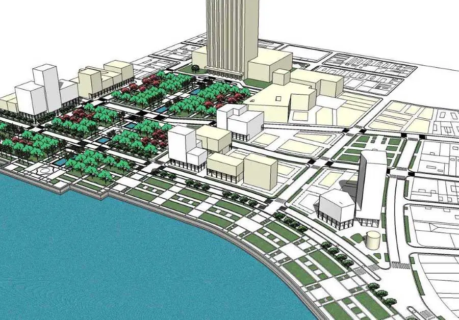
The 2012 Charrette Site, Centro Habana
Centro Habana was the first suburb of Havana and its origins date back from the early 1700s. The increase of the agricultural activity in the rural territories off the walls for granting the Spanish Fleet the necessary supplies and the expanding shipbuilding industry contributed to the birth of the first settlements.
A small church devoted to the Virgin of Guadalupe in 1716 would define the so considered first neighbourhood (at Monte and Aguila streets) while the relocation of the Real Arsenal in 1734 to the South by the Atares area and the layout of the Alameda de Extramuros (Off the Walls Promenade) by the Marquis de la Torre around 1772 also contributed to the expansion of the city. The first cemetery of Havana was built in 1804 – the Espada Cemetery, named after Bishop Espada, while the first hospital outside the walls was built in 1714 (San Lazaro hospital).
The Alameda de Extramuros established a significant urban axis and expressed an early assimilation of the new European trends about the appreciation and enjoyment of Nature in the cities. In 1817 a regulating plan – Plan de Ensanche, the first of its kind in Havana executed by a qualified group of engineers led by Colonel Engineer Antonio Maria de la Torre y Cardenas based on a grid – guided the expansion of the city beyond the walls in an orderly manner by using the existing layout of the roads that connected the walled city with the countryside.
The plan established a hierarchy of streets where the main arteries called ‘calzadas’ would become the most distinctive feature of Havana’s new streetscape and stood in clear contrast with the character of Old Havana. The so called ‘calzadas’ turned into commercial axes later sheltered with Neoclassical porticoes and arcades that signalled the porches as Havana’s trademark. The famous Cuban writer Alejo Carpentier called Havana the City of Columns. This urban pattern can easily be recognized nowadays where the ‘calzadas’ play a role as linear axes that not only define different neighbourhoods but provide a variety of mixed uses.
Centro Habana is the most diverse district of Havana, the most densely populated and the most dilapidated one. Due to construction speculation during the first decades of the 20th century and neglect of almost half a century the district is currently decaying and many buildings have collapsed.
Centro Habana is located to the North and the center of Havana so that The Straits of Florida is the natural limit and The Malecon its physical border to the North while El Cerro district – also named after another ‘calzada’ – is the South border. Old Havana is to the East and El Vedado district is to the West.
For the Master Plan purpose –and also for the Charrette’s – the Centro Habana waterfront sector is defined by the presence of both colonial fortresses, La Punta (1589 -1600)and The Morro Castle (1589 -1630), the Paseo del Prado and the Torreon de San Lazaro (1665). This sector is quite different in character from the harbor and from East Havana in terms of environmental issues, urban landscape, heritage presence, urban and architectural typologies, urban design and architecture.
The challenges are many and huge but the most important one will be the integration of this territory as proposed in the Master Plan following its guidelines and design – urban, landscape and architectural – codes so that the whole waterfront is developed according to both its vocation and its potential to give Havana a new facade related to the sea, that orients new urban development to the sea and creates an urban realm according and a sustainable environment.
Another major challenge will consist in the integration of this area with the rest of Havana in both physical and cultural terms so that it gives continuity to the tradition of excellence of Havana’s urbanism and architecture.
Due to the lack of open space and high density the current population of about 154, 000 is considered to live in extreme environmental conditions with 1.5 Centigrade degree above the average of the city. Green scarcity also contributes to the heat increase even though the breeze coming from the sea seems to occasionally alleviate the situation.
Web site: www.intbau.org
http://intbau.org/component/content/article/158-havana-charrettel
12 Jan 2011
Havana Charrette 2011
Two-part interview with Cuban architect and urban planner Julio Cesar Perez, co-organizer of the annual Havana Charrette, which is currently running in Cuban Art News. Part One went online last Thursday, and Part Two went online on Tuesday.
Link to Havana Charette interview Part One (in English), with Part Two to follow
10 Jan 2011
Havana Charrette exhibition
On December 16 Julio César Pérez (b. San Antonio, 1957) opened an exhibition of architecture and planning at the Eduardo Abela Provincial Gallery in the town of San Antonio de los Baños.
Julio César Pérez graduated from Havana’s School of Architecture in 1982. He has taught and lectured at Harvard University, the Boston Architectural Center, and the University of Toronto. He is the author of Inside Cuba (Taschen, 2006), and The Island: Visions of Cuba (Editorial Samper, 2009).
Link to Havana Charette interview Part One (in English), with Part Two to follow
Cuban Art News is a non-profit website covering Cuban art and culture worldwide. It is sponsored by Fundacion Cuba-Avant Garde, a private foundation with an interest in promoting Cuban culture from a non-political perspective. URL: cubanartnews.org.
Previously:
1 Jun 2009
Havana Harbour Charrette
2009 HAVANA HARBOUR CHARRETTE ATTRACTS INTERNATIONAL ARCHITECTURAL DELEGATION
Thirty architects, landscape architects, planners, and designers from Australia, Europe, North America, and Cuba recently came together for the third Havana Harbour Charrette.
The charrette is organized by the Cuban and Norwegian Chapters of the Council for European Urbanism, and it is conducted with the support of both Cuban and International organisations.*
The charrette is lead by Cuban architect Julio César Pérez Hernández, author of Taschen’s “Inside Cuba” as well as “A Master Plan for XXI Century Havana.”
The purpose of this, and the other two charrettes, is to bring together members of both the international and Cuban design community to propose strategies for implementing the concepts of “A Master Plan for XXI Century Havana.”
In Mr. Pérez Hernández’s words, “the plan is not an official document, but an act of love for the City of Havana and those who live there.”
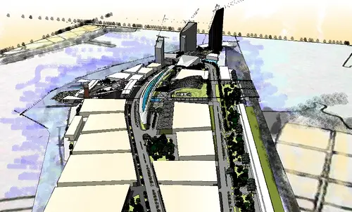
The charrette’s focus is the waterfront revitalization portions of the master plan. The harbor was historically the economic engine of Havana’s economy but like many ports has been hit by its inability to handle large container shipping resulting in obsolescence of the port facilities.
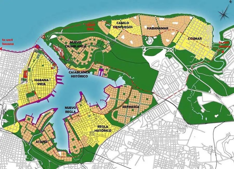
The study area comprises Old Havana, the elevated link from the National Railroad Station, the former powers station of Tallapiedra, the Atarés peninsula, the traditional Afro-Cuban community of Regla, the redundant adjacent oil refinery and the attractive fishing port of Casablanca.
It is generally believed that the harbor’s regeneration can provide a good model for the rest of the city.
The charrette’s strategic development proposals provide for up to 25,000 units of social housing, community services, and infrastructure supported by 2.5 million square meters of for-profit construction for international enterprises.
Proposed commercial activities to be housed in the for-profit buildings build on the capabilities of Cuba’s well-educated workforce. They include extra-care and private housing; health services for international patients; small-scale, clean industry; expanded maritime leisure (including more cruise ships); and a roll- on-roll off ferry terminal.
Casablanca is on the east side of the harbor – connected across a 350 meter strip of water. Its origins were a small fishing village. To-day it is served by a ferry crossing to its south waterfront looking towards Old Havana and a road tunnel connection linking to the highway out of the city taking the traffic east. The topography with its steep escarpment provides a different character to the south scarp.
The charrette engaged with the Casablanca community in an integrated way – reclaiming the waterfront and the scarp behind it, enjoying the historic and cultural elements of the Fort. It built a pattern of integrated uses making a connection between waterfront, education, training and culture, and encouraging revitalisation based on recognition of the beauty of what was there and an encouragement of skills that would allow the area regeneration for its own and a new community to live, learn work and play.
Pérez Hernández commenting on this year’s results, said: “Again, as with the master plan, the three international charrettes held in 2007, 2008 and 2009 have provided a long-term vision and a comprehensive planning strategy for the area for the first time in history.
“Team work stemming from the charrette has produced lots of ideas that encompass the proposal of a spine boulevard along the harbor perimeter to become a buffer zone that grants protection and public space, and allows views to the water.
“The transformation of the current derelict industrial character of the harbor and its conversion into a modern recreational, commercial and sport harbor provides the city with a magnificent opportunity to create new economic and urban values, a new image and a safe environment.
“The harbor, thus, can become a gateway to the city with new mixed-use buildings responding to the waterfront, a new public transportation system that incorporates different means of transport -from bicycles to light rail – and ensures total connectivity,” added, Pérez Hernández.
Roger Zogolovitch, representing the UK-based Academy of Urbanism that was attending the charrette for the first time said: “The charrette was provocative, exciting and a highly creative intervention with contributors drawn from all over the world. The opportunity of engaging with the social, economic, historical and cultural heritage of Havana made the journey memorable.
“The open ended charrette process has the benefit of a two way exchange – of us all learning form the Cuban experience and in our final report leaving our imprint of ideas, emotions and visual response as part of the exciting process of evolution of this extraordinary Caribbean city. The UK Academy of Urbanism welcomes its inclusion and our members present enjoyed the creative engagement.”
The next Havana Harbour Charrette is being planned for late March, 2010.
For additional information, visit the websites at www.cuba.moderno.no, or www.johnpilling.net/Havana_Harbour_Charrette/Homel.
Location: Cuba, northern Caribbean
Architecture in Cuba
Contemporary Architecture in Cuba
Guantanamo Bay Detention Center : Proposal

picture from architect
American Architecture
photo © Andrew McRae
The Cuban Square Architecture Competition, Plaza de la Revolución, Vedado district, west side of Old Havana, Cuba
image courtesy of TerraViva Competitions
The Cuban Square Architecture Competition
Website: Havana Harbor
Comments / photos for the Havana Harbour Charrette Cuba Architecture page welcome