
6 UNESCO Cultural sites virtually rebuilt, Buildings, Architecture Design
6 UNESCO Cultural sites virtually rebuilt
14 Aug, 2020
Reconstructing 6 UNESCO cultural sites in danger of disappearing forever
See ruined endangered UNESCO sites virtually rebuilt before your very eyes
World heritage sites exist in constant danger of degradation or destruction. From militants to motorists, earthquakes to urbanization, these meaningful landmarks face both human-made and natural threats. UNESCO’s List of World Heritage in Danger draws attention to sites at risk of losing the characteristics that make them special.
By definition, these structures are significant to “all the peoples of the world” – but most of us won’t get to see them in person. The team at Budget Direct decided to bring them to your home instead. These six ruined sites were digitally restored to their former glory:
UNESCO World Heritage Site – Location
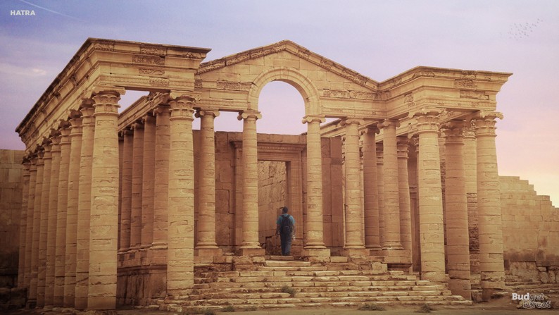
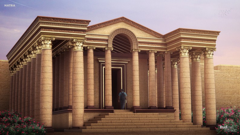
1) Hatra Al-Jazīrah – Iraq
2) Leptis Magna District of Khoms – Libya
3) Palmyra Tadmur, Homs Governorate, Syria
4) Portobelo-San Lorenzo Fortifications Province of Colon, District of Cristobal, Panama
5) Nan Madol Temwen Island, Federated States of Micronesia
6) Old City of Jerusalem and its Walls Jerusalem, Israel
Here’s a before and after preview of Iraq’s Hatra (also available in GIF and video format):
Before (now) After (digital reconstruction)
This project is part of a series of campaigns released by the Budget Direct Travel Insurance team exploring how ruined structures would look like had they been preserved.
The team decided to bring to life a series of cultural heritage sites that UNESCO has categorised as ‘in danger’ – from the fortified city of Hatra in Iraq to the recently destroyed ruins of Palmyra in Syria.
Methodology
Budget Direct started by researching sites on the World Heritage in Danger list, which includes the 53 properties that the World Heritage Committee has deemed “in danger.” They selected sites that were man-made and had some elements remaining. They decided not to include natural sites, or sites for which accurate historical and design information was unavailable. The team worked with architects Jelena Popovic and Keremcan Kirilmaz, and industrial designer Erdem Batirbek to research and illustrate these intricate reconstructions.
Research Notes
1. Hatra
Location: Al-Jazīrah – Iraq (Google maps)
Year built: 3rd or 2nd century BC
History: A large fortified city under the influence of the Parthian Empire and capital of the first Arab Kingdom, Hatra withstood invasions by the Romans in A.D. 116 and 198 thanks to its high, thick walls reinforced by towers. Hatra was probably founded in the 3rd or 2nd century BCE, under the Seleucid kingdom. It rose to prominence as the capital of Araba, a small semi autonomous state under Parthian influence. Because of its strategic position along caravan trade routes, the town prospered and became an important religious centre.
Architectural features:
● High, thick walls reinforced by towers.
● It is encircled by inner and outer walls nearly 4 miles (6.4 km) in circumference and supported by more than 160 towers.
● A temenos (temple enclosure) surrounds the principal sacred buildings in the city’s centre.
● The temples cover some 3 acres (1.2 hectares) and are dominated by the Great Temple, an enormous structure with vaults and columns that once rose to 100 feet (30 metres).
● Numerous sculptures and statues have also been discovered in the city.
● Built in a circular plan of military tradition.
● Hellenistic and Roman architecture blend with Eastern decorative features
2. Leptis Magna
Location: District of Khoms – Libya (Google maps)
Year built: 7th c. BC
Before & After:
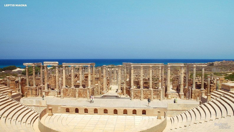
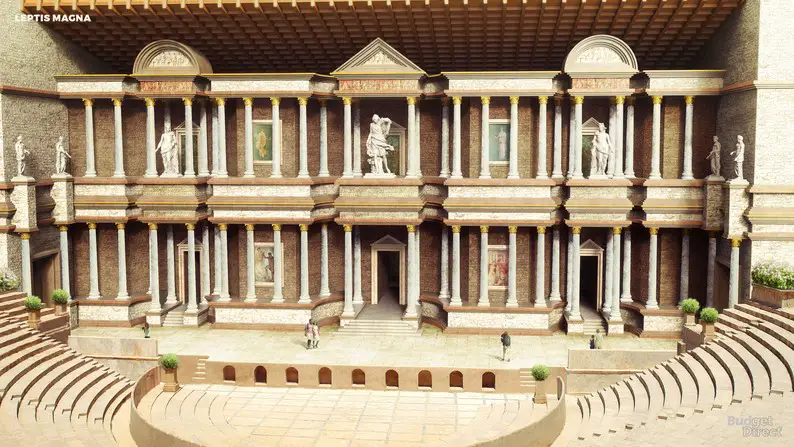
History: Leptis or Lepcis Magna, also known by other names in antiquity, was a prominent city of the Carthaginian Empire and Roman Libya at the mouth of the Wadi Lebdam in the Mediterranean. Leptis Magna was enlarged and embellished by Septimius Severus, who was born there and later became emperor. It was one of the most beautiful cities of the Roman Empire, with its imposing public monuments, harbour, market-place, storehouses, shops and residential districts.
Architectural features:
1. Amphitheater
● Built in AD 56. Old quarry for construction.
● The oval arena measures 57 x 47 m.
● The lower ranks were for the Lepcitanian elite, we still see the stone slabs that were once on the seats. Among these is an altar for Nemesis, the goddess of doom.
● It is likely that there was some sort of (wooden) portico surrounding the amphitheater: these were the cheaper seats.
2. Theater
● Built in the 1st century AD, construction was financed by several rich aristocrats.
● The upper part of the stands was not excavated from the hill, but built from natural stone, concrete, and bricks.
● Five flights of steps enabled the people to enter and leave the building, and divided the stands into six wedge-like segments.
● On the upper edge, a colonnaded walk was erected, which offered shade to the higher seats, where the poorer people sat. The front ranks were occupied by the city’s wealthiest citizens, with a tribunal for the magistrates.
● A small temple was added to the colonnaded walk in 35 or 36, dedicated to the goddess Ceres Augusta.
● Another addition was the semicircular wall surrounding the orchestra. Behind the stage of the theater was a trapezoidal construction that was called Porticus post scaenam by ancient architects. It is a square garden, surrounded by colonnades; in the center was a temple.
3. Hippodrome (Circus)
● 40 m long racecourse, built in the 2nd century AD.
● Measures about 100 x 450 m. Eleven rows of official seats.
● At the spina (the median strip), five water basins with fountains were added, a type of decoration otherwise only known from Rome’s Circus Maximus, fitting the “dolphins” on the corners, which indicated how many laps the charioteers still had to cover.
4. Market
● Initially market was built here in the 9th century AD, but present structures were built in the times of Septimius Severus.
● Consisted of a large square, surrounded by a portico, in which two octagonal buildings were placed, which are known to archaeologists as tholoi.
3. Palmyra
Location: Tadmur, Homs Governorate, Syria
Year built: 3rd millennium BC
Before & After:
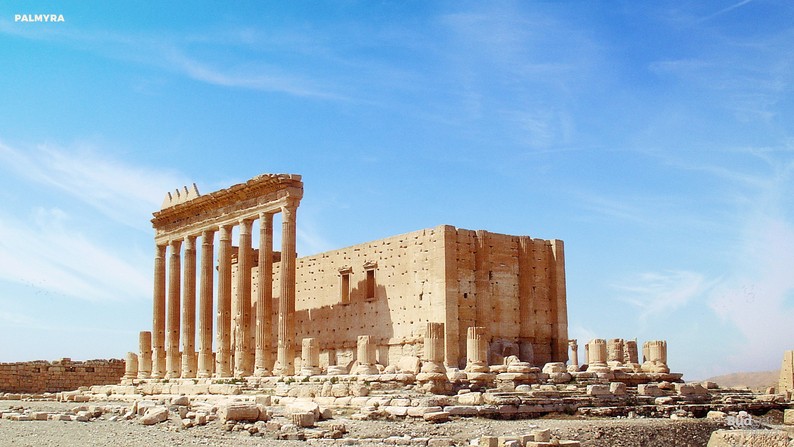
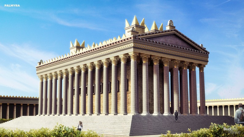
History: An oasis in the Syrian desert, north-east of Damascus, Palmyra contains the monumental ruins of a great city that was one of the most important cultural centres of the ancient world. From the 1st to the 2nd century, the art and architecture of Palmyra, standing at the crossroads of several civilizations, married GraecoRoman techniques with local traditions and Persian influences.
Architectural features:
● Enclosed by a massive wall flanked with traditional Roman columns, Bel’s sanctuary plan was primarily Semitic. Similar to the Second Temple, the sanctuary consisted of a large courtyard with the deity’s main shrine off-center against its entrance (a plan preserving elements of the temples of Ebla and Ugarit).
● Palmyra began as a small settlement near the Efqa spring on the southern bank of Wadi al-Qubur. Palmyra’s architecture was influenced by the Greco-Roman style, while preserving local elements (best seen in the Temple of Bel).
● Along the principal 1.1-kilometre-long (0.68 mi) east-west street, named the Grand Colonnade, a double portico is ornamented with three nymphaea.
● It extended from the Temple of Bel in the east, to the Funerary Temple no.86 in the city’s western part. It had a monumental arch in its eastern section, and a tetrapylon stands in the center. The Baths of Diocletian were on the left side of the colonnade.
● Nearby were residences, the Temple of Baalshamin, and the Byzantine churches, which include “Basilica IV”, Palmyra’s largest church. The church is dated to the Justinian age, its columns are estimated to be 7 metres (23 ft) high, and its base measured 27.5 by 47.5 metres (90 by 156 ft).
● The Temple of Nabu and the Roman theater were built on the colonnade’s southern side.
● Behind the theater were a small senate building and the large Agora, with the remains of a triclinium (banquet room) and the Tariff Court. A cross street at the western end of the colonnade leads to the Camp of Diocletian, built by Sosianus Hierocles (the Roman governor of Syria).] Nearby are the Temple of Al-lāt and the Damascus Gate.
● In architecture the Corinthian order marks almost all the monuments, but the influence of Mesopotamia and Iran is also clearly evident.
● Notable structures:
1. Baths of Diocletian
● The complex’s entrance is marked by four massive Egyptian granite columns each 1.3 metres (4 ft 3 in) in diameter, 12.5 metres (41 ft) high and weigh 20 tonnes.
● Inside, the outline of a bathing pool surrounded by a colonnade of Corinthian columns is still visible in addition to an octagonal room that served as a dressing room containing a drain in its center. Sossianus Hierocles, a governor under Emperor Diocletian, claimed to have built the baths, but the building was probably erected in the late second century and Sossianus Hierocles renovated it.
2. Temple of Bel
● Dedicated in AD 32
● It consisted of a large precinct lined by porticos; it had a rectangular shape and was oriented north-south.
● The exterior wall was 205-metre (673 ft) long with a propylaea, and the cella stood on a podium in the middle of the enclosure.
3. Senate building
● Largely ruined.
● It is a small building that consists of a peristyle courtyard and a chamber that has an apse at one end and rows of seats around it.
4. Roman Theatre at Palmyra
● The second-century CE theatre was built in the center of a semicircular colonnaded piazza which opens up to the South Gate of Palmyra.
● The 82-by-104-metre (269 by 341 ft) piazza was located to the south-west of the main colonnaded street.
● The unfinished cavea is 92 metres (302 ft) in diameter and consists only of an ima cavea, the lowest section of the cavea, directly surrounding the orchestra. The ima cavea is organized into eleven cunei of twelve rows each and faces north-northeast towards the cardo maximus.
● The theatre’s aditus maximi, its main entrances, are 3.5 metres (11 ft) in width, and lead to a stone-paved orchestra with a diameter of 23.5 metres (77 ft). The orchestra is bounded by a circular wall with a diameter of 20.3 metres (67 ft). The proscenium wall is decorated with ten curved and nine rectangular niches placed alternately. The stage measures 45.5 by 10.5 metres (149 by 34 ft) and is accessed by two staircases.
● The scaenae frons had five doors: the main entrance, or valve regia, built into a broad curved niche; two guest doors on either side of the valve regia, or valve hospitalis, built into shallow rectangular niches; and two extra doors, at either end of the stage.
● Emperor Nero is known to have placed his statue in the niche of the regia of the theatre at Palmyra. The columns at the stage are decorated in the Corinthian order.
5. Palmyra Castle, also known as Fakhr-al-Din al-Ma’ani Castle or Tadmur Castle
● The castle is thought to have been built by the Mamluks in the 13th century on a high hill overlooking the historic site of Palmyra.
● The castle lying on raised bedrock was a well defended position for a fortification with thick and high walls, which was also surrounded by a moat that had only one access available through a drawbridge.
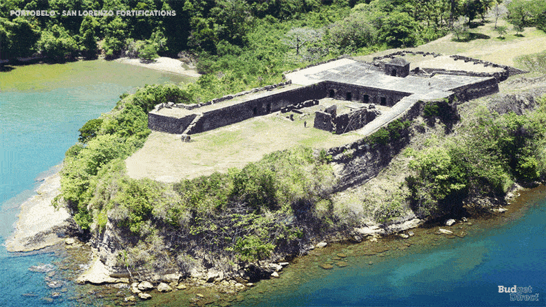
4. Portobelo-San Lorenzo fortifications
Location: Province of Colon – District of Cristobal, Panama
Year built: 17th and 18th century
Before & After:
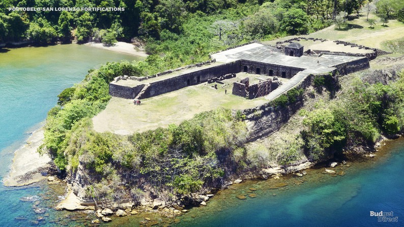
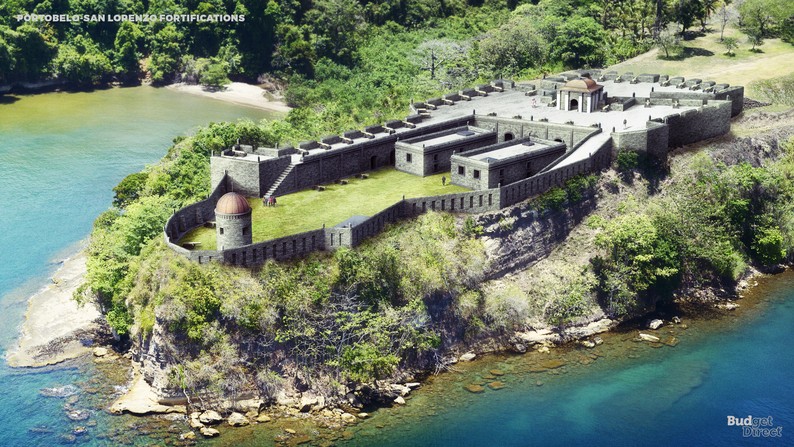
History: Magnificent examples of 17th- and 18th-century military architecture, these Panamanian forts on the Caribbean coast form part of the defence system built by the Spanish Crown to protect transatlantic trade.
click on the image to see the changes in time:
There are diverse fortification sites around the Bay of Portobelo, denominated San Fernando fortifications: Lower Battery, Upper Battery and Hilltop Stronghold; San Jerónimo Battery Fort; Santiago fortifications: Castle of Santiago de la Gloria, Battery and Hilltop Stronghold; the old Santiago Fortress; ruins of Fort Farnese; the La Trinchera site; the Buenaventura Battery; and the San Cristóbal site. Forty-three kilometers away, at the mouth the Chagres River stands the San Lorenzo Castle (originally “San Lorenzo el Real del Chagre”) with its Upper Battery as a separate structure.
Architectural features:
● The Bay of Portobelo has many fortifications, which replicate European designs of military architecture, built during the colonial period (1596–99). The structures built in the earlier years were in medieval style (Antonelli’s Spanish designs). However, in the 18th century, the structures were built by renovating neo-classical features (of Salas and Hernandez (1753–60)), as seen at the Santiago Fort, San Jeronimo Fort and San Fernando Fort, and the San Lorenzo Fort.
● From 1587 to 1599, the fortifications evolved into a sea-level battery and they were completed in 1601. The plans of the massive fortress were made by the Italian engineer Baptist Antonelli.
● The castle of San Lorenzo was built on top of a high reef, in a position that dominated the entrance of the Chagres River.
● In 1670, buccaneer Henry Morgan ordered an attack that left Fort San Lorenzo in ruins. He invaded Panama City the following year, using San Lorenzo as his base of operations.
● In the 1680s, the Spanish constructed a new fort 80 feet (24 m) above the water. Set on a cliff overlooking the entrance to the harbor, the fort was protected on the landward side by a dry moat with a drawbridge. During this time, the town of Chagres was established under the protection of the fort.
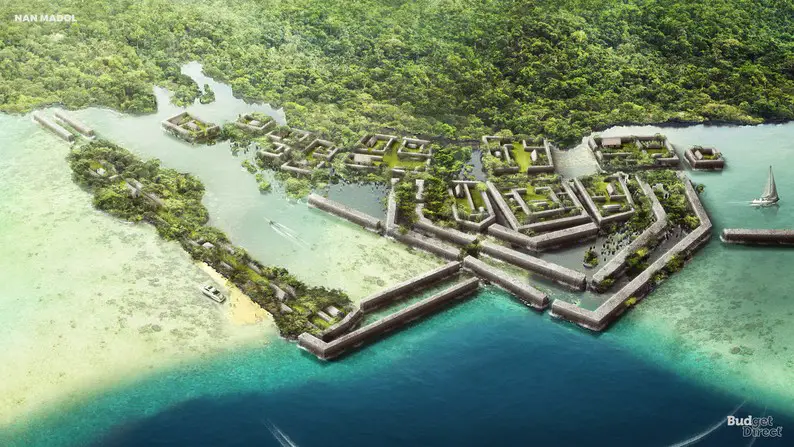
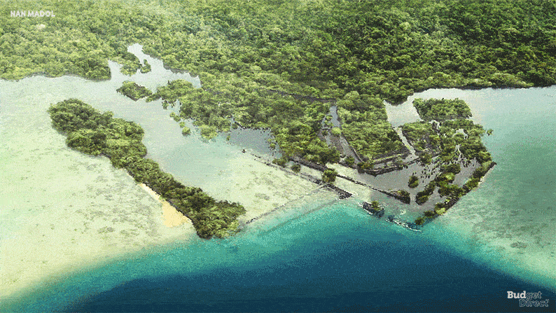
5. Nan Madol
Location: Temwen Island, Federated States of Micronesia
Year built: 8th or 9th century
Before & After:
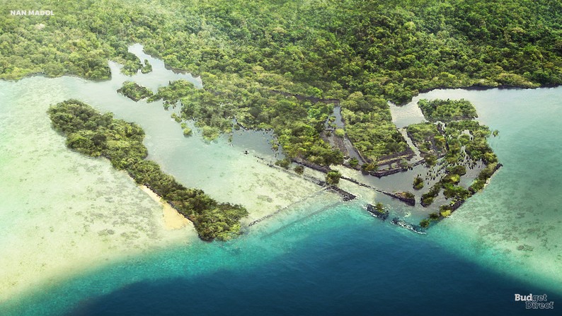

History: Nan Madol is a series of more than 100 islets off the south-east coast of Pohnpei that were constructed with walls of basalt and coral boulders. These islets harbour the remains of stone palaces, temples, tombs and residential domains built between 1200 and 1500 CE. These ruins represent the ceremonial centre of the Saudeleur dynasty, a vibrant period in Pacific Island culture.
click on the image to see the changes in time:
The huge scale of the edifices, their technical sophistication and the concentration of megalithic structures bear testimony to complex social and religious practices of the island societies of the period. The site was also inscribed on the List of World Heritage in Danger due to threats, notably the siltation of waterways that is contributing to the unchecked growth of mangroves and undermining existing edifices.
Architectural features:
● The site core with its stone walls encloses an area approximately 1.5 km long by 0.5 km wide and it contains nearly 100 artificial islets–stone and coral fill platforms–bordered by tidal canals.
● It spread over 200 acres abutting Pohnpei’s mangrove-covered shore.
● Most of it was built from the 13th to the 17th centuries by the Saudeleurs, descendants of two brothers of unknown provenance who founded a religious community in the sixth century focused on the adoration of the sea. They and their successors brought from the other side of the island columns of black lava rock up to 20 feet long that are naturally pentagonal or hexagonal and straight. They used them in a log cabin formation to build outer walls as well as foundations filled in with lumps of coral to create elevated platforms where traditional thatched structures were used as lodgings.
● Islet of Pahnwi wall has huge, flat-sided stone rises 58 feet and encloses a tomb.
● Nandowas is by far the most elaborate building. It’s the royal mortuary, with two sets of 25-foot-high walls whose gracefully up-swept corners cover an area greater than a football field. One cornerstone is estimated to weigh 50 tons. Eight columns form the basis of a roof of the moss-encrusted tomb that lets in shards of sunlight.
Note: Computer based reconstruction of main islets and features, including selected house structures. The main Pahn Kadira (PKI) islet, the residential complex of the Sau Deleur chiefs, is 115 meters long.
6. Old City of Jerusalem and its Walls
Location: Jerusalem, Israel
Year built: 1535
Before & After:
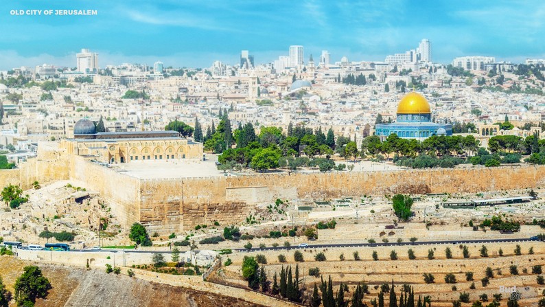
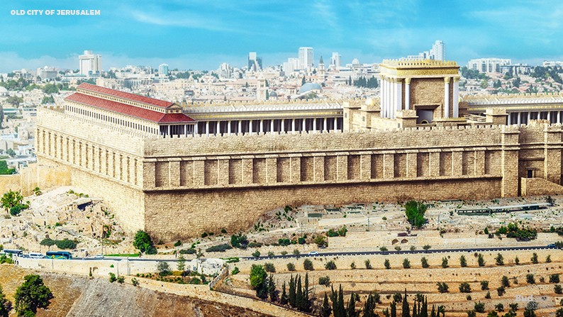
History: The Walls of Jerusalem surround the Old City of Jerusalem (approx. 1 km²). In 1535, when Jerusalem was part of the Ottoman Empire, Sultan Suleiman I ordered the ruined city walls to be rebuilt. The work took some four years, between 1537 and 1541.
The length of the walls is 4,018 meters (2.4966 mi), their average height is 12 meters (39.37 feet) and the average thickness is 2.5 meters (8.2 feet). The walls contain 34 watchtowers and seven main gates open for traffic, with two minor gates reopened by archaeologists.
Architectural features:
● Herod’s Temple was one of the larger construction projects of the 1st century BCE. It was Herod’s plan that the entire mountain be turned into a giant square platform. The Temple Mount was originally intended to be 1600 feet wide by 900 feet broad by 9 stories high, with walls up to 16 feet thick, but had never been finished. To complete it, a trench was dug around the mountain, and huge stone “bricks” were laid.
● The Western Wall, Wailing Wall, or Kotel, known in Islam as the Buraq Wall is an ancient limestone wall in the Old City of Jerusalem. It is a relatively small segment of a far longer ancient retaining wall, known also in its entirety as the “Western Wall”. The wall was originally erected as part of the expansion of the Second Jewish Temple begun by Herod the Great, which resulted in the encasement of the natural, steep hill known to Jews and Christians as the Temple Mount, in a huge rectangular structure topped by a flat platform, thus creating more space for the Temple itself, its auxiliary buildings, and crowds of worshippers and visitors.
References
Unesco (2020). Hatra. unesco.org
Wikipedia. (2020). Hatra. wikipedia.org
Wikipedia. (2020). Leptis Magna. wikipedia.org
Livius.org. (2020). Lepcis Magna, Amphitheater. livius.org
Livius.org. (2020). Lepcis Magna, Theater. livius.org
Livius.org. (2020). Lepcis Magna, Circus. livius.org
Livius.org. (2020). Lepcis Magna, Macellum. livius.org
Unesco (2013). Site of Palmyra. unesco.org
Wikipedia. (2020). Palmyra. wikipedia.org
Britannica. (2020). Palmyra. britannica.com
Wikipedia. (2020). Palmyra Castle. wikipedia.org
Unesco (2020). Fortifications on the Caribbean Side of Panama: Portobelo-San Lorenzo. unesco.org
Wikipedia. (2020). Fortifications on the Caribbean Side of Panama: Portobelo-San Lorenzo. wikipedia.org
Wikipedia. (2020). Chagres and Fort San Lorenzo. wikipedia.org
Unesco (2020). Nan Madol: Ceremonial Centre of Eastern Micronesia. unesco.org
Smithsonianmag (Christopher Pala). Nan Madol: The City Built on Coral Reefs. smithsonianmag.com
Discovermagazine (Corey S. Powell). A Space-Age Journey into the Past with Albert Lin. discovermagazine.com
Wikipedia. (2020). Walls of Jerusalem. wikipedia.org
Wikipedia. (2020). Western Wall. wikipedia.org
Wikipedia. (2020). Second Temple. wikipedia.org
About Budget Direct
Budget Direct has been offering Simply Smarter insurance since 2000. They have insured over 1.5 million Australians since then. Their policies are underwritten by Auto & General Insurance Company Limited, an Australian insurance company regulated by APRA and a member of the Insurance Council of Australia.
Budget
Direct has won Money magazine’s Insurer of the Year award again in 2018 (they also won this prestigious award in 2017, 2015 & 2010). Also, Budget Direct is the only provider to have won the coveted CANSTAR award for ‘Outstanding Value Car Insurance’ every year since 2007. Recently adding the 2019 CANSTAR national award to its long list, that’s 13 years in a row!
Credit Information: article by Budget Direct Travel Insurance
About NeoMam Studios
NeoMam Studios is a creative studio based in the UK. We are on a mission to create digital content that online
audiences will want to share.
Architecture – Major Buildings
Kuwait Towers, Kuwait City, Kuwait (architect: Malene Bjørn, 1976)

photo © Adrian Welch
Kuwait Towers
Oscar Niemeyer’s Permanent International Fairground in Tripoli, Lebanon:

photo © UNESCO Beirut Office
Getty Foundation 2018 Keeping it Modern Grants
Sidi Harazem Thermal Bath Complex, Sidi Harazem, Morocco (architect: Jean-François Zevaco);

Image © Frac Centre-Val de Loire Collection.
Sidi Harazem Thermal Bath Complex Building
Comments / photos for the 6 UNESCO Cultural sites virtually rebuilt page welcome