
Rio Favelas, Rocinha, Brazil Building Project News, Design, Property Images
Rocinha – Favelas Rio de Janeiro
Rio Favelas Project, Brazil, South America design by Lee Miles of Desitecture
page updated 30 Jul 2016 ; 16 Aug 2010
Rocinha – Rio Favelas
Favelas in Rio
Design: Lee Miles, Desitecture
Introduction
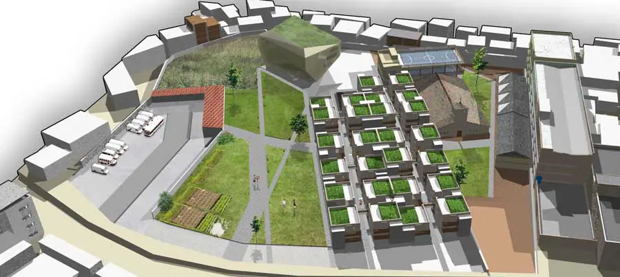
For my final MA project I intend to explore the potential of urbanism and nature within a specific site. My initial MA studies began with rather simplistic sites, in very comfortable areas.
Due to this it meant the concepts were also slightly simplistic, as they struggled to draw inspiration from a relatively mundane set of factors and influences. It was my intention to gradually ramp up the complexity of each project along the course of the MA.
To reach the other end of the spectrum and test my ideas in a more challenging environment it is necessary to add in more unique and complex socio economic factors outside my comfort zone to truly test whether any design proposal that seeks to integrate nature is truly viable and effective.
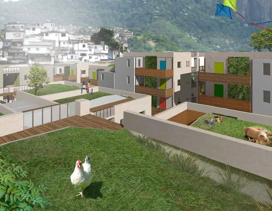
images : Lee Miles
I settled on exploring the Rio de Janeiro Favelas as an ideal testing ground for the proposal.
The reason being is because it is a new unknown territory for me as I’ve little or no experience of South American culture, so it should prove interesting and dynamic, but also should mean I have no preconceived conceptions as to how the project should work.
But more importantly the site fulfils each and every criteria I initially hoped for. Rio is a fascinating city. Here it has a contrasting, and extremely polarised, class system.
The distance between the wealthy areas and the poor district is incredibly small. Here we can witness the formalised, organised, city harbouring the informal and organic favelas which grow almost as parasites upon the city’s fringe. But the term parasite is an unfair label.
These informal areas contribute back to the formal city by housing many of the cities workers and labour force. But more importantly they act as homes to the waves of migrants hoping for a better life.
However it is the conditions within these favelas that add an extra dimension to the project. Within these dangerously formed, and somewhat insalubrious, unplanned extensions to the city inhabitants live under very tough, “unnatural”, conditions. Water and power are luxuries.
The ordered systems that manifest within the confines of the formal environment are replaced here with a more chaotic method. The self built houses are overseen by landlords that often deal in the drugs trade and other explicit activities that are illegal in the formal areas, mainly motivated purely by a need to survive. As a result running internal battles between different favela gangs and also between the police enforcement from the city make the favelas unpredictable and unstable places. But a bigger picture is emerging here.
The slums spawning from Rio de Janeiro are not an isolated case. Globally we are witnessing a steady exponential growth of informal, unregulated, towns. From Rio to Mumbai, Nairobi, and Lagos; informal living has become a global trend. Critical speculation even suggests these slums represent the future of most cities and urban environments.
History of the favelas
The original favela settlements – Quilombos In the late 19th century, the first settlements were called Bairros Africanos or Quilombos, and they were the place where former slaves with no land ownership and no options for work lived. Over the years, many freed black slaves and former soldiers moved in.
However, long before the first settlements called “favela” came into being; poor blacks were pushed away from downtown into the far suburbs. The first favelas It is generally agreed upon that the first favela was created in November 1897 when 20,000 veteran soldiers were brought to Rio de Janeiro and left with no place to live.
Interestingly the favelas were formed prior to the dense occupation of cities and the domination of real estate interests. The housing crisis of the 1940s forced the urban poor to erect hundreds of shanty towns in the suburbs, when favelas replacedtenements as the main type of residence for destitute cariocas (residents of Rio).
The explosive era of favela growth dates from the 1940s, when Getúlio Vargas’s industrialisation drive pulled hundreds of thousands of migrants from rural areas into coastal cities until 1970, when shanty towns expanded beyond urban Rio and into the metropolitan periphery.
Removal programs
A program in the 1940s called Parque Proletário destroyed the original homes of those dwelling in favelas in Rio and relocated them to temporary housing as they waited for the building of public housing. Eventually little public housing was built and the land that was cleared for it just became reoccupied with new settlements of favela dwellers.
Removal programs of the favelas flourished once again in the 1970s under the military dictatorship, disguised as a government housing program for the poor. What really happened was that more favelas were eliminated and their residents were displaced to urban territory lacking basic infrastructure.
The idea was to eliminate the physical existence of favelas by taking advantage of the cheaper prices of suburban land. The favela eradication program became paralyzed eventually because of the resistance of those who were supposed to benefit from the program.
The current favelas
Most of the current favelas began in the 1970s, as a construction boom in the richer neighborhoods of Rio de Janeiro initiated a rural exodus of workers from poorer states in Brazil. Heavy flooding in the low-lying slum areas of Rio also forcibly removed a large population into favelas, which are mostly located on Rio’s various hillsides. Since then favelas have been created under different terms but with similar end results, the term favela has become generally interchangeable with any impoverished areas.
Favelas are built around the edge of the main city so in a way they are actually expanding the city. Attempted gentrification. The people who live in favelas are known as Moradores da favela, or pejoratively as favelados. Favelas are associated with immense poverty. Another attempt to deal with urban poverty came by way of gentrification.
The government sought to upgrade the favelas and integrate them into the inner city with the newly urbanized upper-middle class. As these “upgraded favelas” became more stable, they began to attract members of the lower-middle class pushing the former favela dwellers onto the streets or outside of the urban centre and into the suburbs further away from opportunity and economic advancement.
For example: in Rio de Janeiro, the vast majority of the homeless population is black, and part of that can be attributed to favela gentrification and displacement of those in extreme poverty Currently, it is estimated, that one third of Rio’s urban population live in more than 500 favelas. The number of people living in favelas is growing at an annual rate of some 7.5 per cent, whereas the overall population of Rio de Janeiro is only increasing by 2.5 per cent per year.
Rio de Janeiro is not the only South American city with this type of squatter settlements. But what makes Rio’s favelas unique is their locations. Most of them are situated on hillsides offering panoramic views over the city and the ocean, while the affluent areas are located at the bottom of the hills. In most other cities in the world, it the rich who occupy hillside locations while the poor live in less favourable low-lying areas.
Rio de Janeiro
Rio de Janeiro is famous for its natural settings, its carnival celebrations, samba and other music, and hotel-lined tourist beaches, such as Copacabana and Ipanema. Some of the most famous landmarks in addition to the beaches include the giant statue of Christ, known as Christ the Redeemer atop Corcovado mountain, named one of the New Seven Wonders of the World; Sugarloaf mountain with its cable car; the Sambódromo, a giant permanent parade stand used during Carnival and Maracanã stadium, one of the world’s largest football stadiums.
The city also boasts the largest and second largest urban forests in the world: Floresta da Tijuca, and the forest in Parque Estadual da Pedra Branca, or White Stone State Park. The Galeão-Antônio Carlos Jobim International Airport, commonly known simply as Galeão connects Rio de Janeiro with many Brazilian cities and also operates several international flights. Despite its charm and beauty, Rio is reputed to be one of the most violent cities in the world and motivated movies such as Bus 174, City of God and Elite Squad portraying severe social issues.
Much of the violent crime is concentrated in the favelas or shantytowns but it also spills into middle- and upper-income neighbourhoods. In Rio, unlike other major cities, many of the slums are directly adjacent to some of the wealthiest areas of the city.
Guanabara Bay was first discovered on January 1, 1502 (hence Rio de Janeiro, “January River”) by a Portuguese expedition under explorer Gaspar de Lemos. In the late 17th century, when the Bandeirantes found gold and diamonds in the neighboring captaincy of Minas Gerais, Rio de Janeiro became a much more useful port for exporting wealth than Salvador, Bahia, which is much farther to the north and in 1763, the colonial administration in Portuguese America was moved to Rio.
The city remained primarily a colonial capital until 1808, when the Portuguese royal family and most of the associated Lisbon nobles, fleeing from Napoleon’s invasion of Portugal, moved to Rio de Janeiro.
The kingdom’s capital was transferred to the city. As there was no physical space or urban structure to accommodate hundreds of noblemen who arrived suddenly, many inhabitants were simply evicted from their homes.There was a large influx of African slaves to Rio de Janeiro: in 1819, there were 145,000 slaves in the captaincy. In 1840, the number of slaves reached 220,000 people Until the early years of the 20th century, the city was largely limited to the neighborhood now known as the historic Downtown business district, on the mouth of Guanabara Bay.
The city’s center of gravity began to shift south and west to the so-called Zona Sul (South Zone) in the early part of the 20th century, when the first tunnel was built under the mountains located between Botafogo and the neighbourhood now known as Copacabana.
That beach’s natural beauty, combined with the fame of the Copacabana Palace Hotel, the luxury hotel of the Americas in the 1930s, helped Rio to gain the reputation it still holds today as a beach party town (though, this reputation has been somewhat tarnished in recent years by favela violence resulting from the narcotics trade). The city is commonly divided into the historic downtown (Centro); the tourist-friendly South Zone (Zona Sul), with its world-famous beaches; the residential North Zone (Zona Norte); and the West Zone (Zona Oeste), with the newer Barra da Tijuca district.
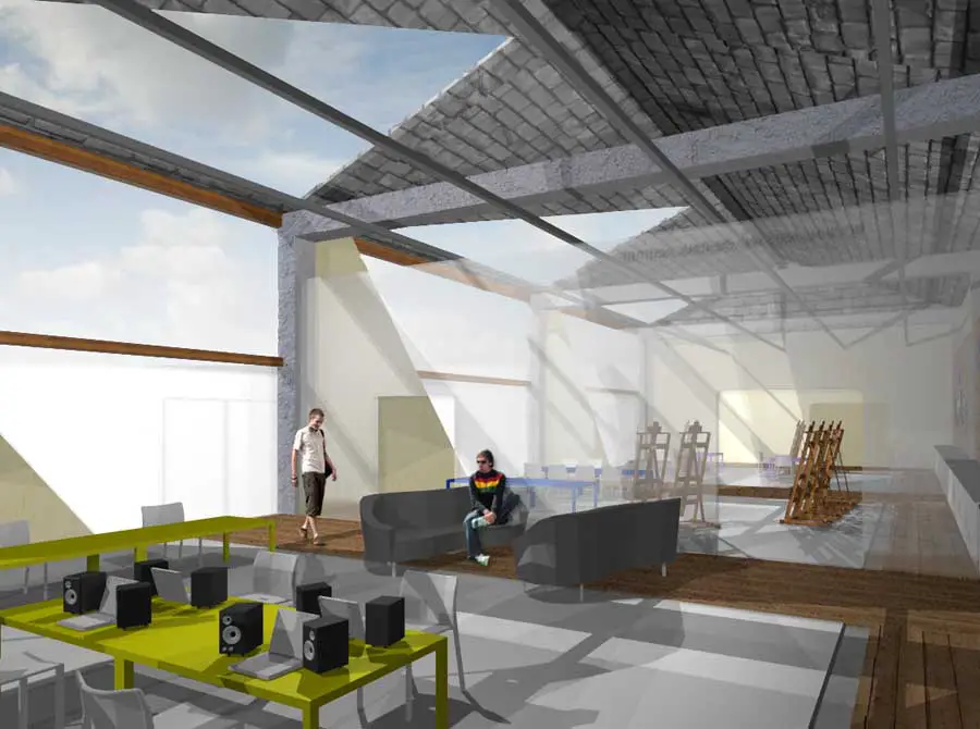
images : Lee Miles
Favelas in rio
The reasons for choosing Rio de Janeiro over other Brazilian cities have been considered carefully. Theres a clear list of estimated favela inhabitants throughout Brazil, and this is dominated by São Paulo, Rio de Janeiro and other cities such as Salvador and Curitiba Rio was selected mainly because the geographical constraints are so extreme and contrasting.
The steep mountains curve out into the flat low lands that eventually become the ocean. Very flat favelas or informal towns are present and unfortunately common place throughout most of South America.
But in Rio it is very easy to assume that building up a hill side would form an instant deterrent. But the fact remains that this hasn’t actually stopped favelas creeping up the cliff sides and morphing into the terrain suggests huge determination. It is a unique condition of the site, and represents an interesting aspect that could inform the design.
Rocinha favela
Rocinha was selected as perhaps the most suitable site to take, as it is the most famous and well known favela in Rio de Janeiro. It is arguably the largest with 127,000 residents and is relatively peaceful with occaisonal organised tours through the favela.
Rocinha has also seen some attempts at improvement and development recently as the government seeks to gentrify the area and as such benefits from better infrastructure, but is still characterised by the same issues affecting the other favelas. This development however could mean the project is slightly unfair as it doesn’t fully represent the more general, less gentrified, informal areas of Rio.
It does however still contain significant problems that need addressing. Rocinha is also one of the principal points of drug trafficking in Rio, generating an estimated $3.3 million each year. Frequent “Bailes” or favela parties, often draw in tourists seeking an authentic taste of favela life. Its here the majority of the drug trade happens. This drug trade subsidises the low running costs of the favelas. Higher up the hill lie the parts of Rocinha that are largely controlled by drug lords, not the city authorities.
The wealthier and more cleaner areas are positioned nearest the city area, with a spectrum of class and order detioriating significantly as the favelas spread out up the mountainside. Key issues that hinder rochina are include a dependency on the drug trade, limited infrastructure, no sewers mean rife disease. Geographical issues include rock slides and flooding, as water and debris often fall down the mountainside.
Rocinhas history
Rocinha’s history began in the 1920s when the first clusters of shacks were noticed. The worldwide economic depression of the late 1920s was partially responsible for the massive rural to urban migration, with many destitute migrants moving to Rio’s emerging favelas, such as Rocinha.
The name Rocinha means “small ranch” in Portuguese, and is a reference to the horse ranch that was positioned within the site before the favela. Rocinha’s fastest growth occurred during the 1950s and 1960s; largely influenced by the destruction of several nearby favelas, the continuation of the rural to urban exodus, and the real-estate boom in the surrounding upper-class neighbourhoods.
By the 1960s, Rocinha was considered Rio de Janeiro’s largest favela, and many claimed it to be the largest slum in all of Latin America. Today, brick and concrete houses have replaced wooden shanties as the most popular for of construction, with some buildings as tall as 7, 8, 9, and even 11 stories tall.
Most houses in Rocinha have basic sanitation, plumbing, and electricity. Despite this natural disasters such as flooding still wreak havoc and cost lives within Rocinha. Hundreds of residents died in 1988 during floods that ran down deforested hillsides into the favelas. Also in 1996, several Rocinha families were killed in a rock-fall.
This is due to the precarious nature of the houses next to the mountainside. There are roughly 21 neighborhoods within Rocinha yet the community only occupies an area of approximately 0.86 km² The current community has a population estimated at around 250,000 inhabitants, who live crammed into a steep and rugged landscape of the aforementioned 0.86km.
Where is Rocinha?
A big problem with redesigning the favelas is technically they are not recoginised by the local government. They keep no records of the areas history or development. Also because of the sporadic and fluctuating nature of the favela urban condition, there are no plans or drawings of the layout or design of the environment. This makes it very difficult to accurately re-design the area. All we can do is propose guidelines, or a standardised system suitable for most favela dwellings.
This also means for the sake of urban planning we have to rely on satellite imagery such as google earth as no other maps or plans exist! An aerial view of Rocinha highlights shows the favela in its entirety below. Rocinha varies slightly from most favelas because at its centre a main street runs through it, from the eastern town of San Conrardo to the affluent western suburb of Gavea. (Street indicated by yellow line) Some favelas, especially those in São Paulo are free to expand quickly across more flat terrain.
There are a few flat favelas in Rio, with a few also on single hill sides. But Rocinha is situated between two hills. This could hold some design advantages but overall it makes life difficult for the residents. These differences aside it does however bear the hallmarks of most favelas in that the dwellings have developed up the side of the mountain face and have very bad street access throughout. The sprawl has only been stopped by it hitting the sides of two formalised towns and also being hindered by the verticality of the mountainside.
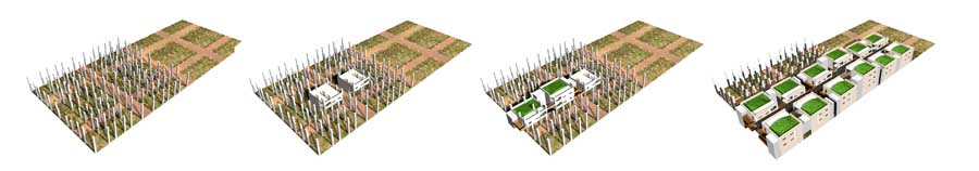
Typical favela houses
Favela houses are built like most of their global counterparts, via a sporadic construction process that hinges on how much the owner can invest. The money is spent gradually on improving the house. The favela owners seldom move between other favela houses instead opting on improving the house they rent or own from the landlord. The buildings are relatively unplanned and as such is prone to collapse very easily. Also what is noticeable is the irregular shapes, haphazard power cabling and no drainage or planned water runoff.
Social structure within the favela
To suggest the favelas have no formalised system or organisation would be a wrong assumption to make. The favelas have actually developed over time a model of social structuring that ensure they run and work in an ordered fashion.
Essentially each favela is maintained by a landlord. This landlord leases the favela houses to the favela dwellers and also new migrants that have moved to the city but can’t afford formalised housing. The next tier in this hierarchy consists of the internal services, NGO’s and the drug faction. Unfortunately the drug faction has a strong hold over the landlord. This bond varies on how informal the favelas are.
The drug dealers basically protect the favela and its inhabitants from rival drug gangs and police, but also importantly provide a key form of income for the landlord to spend on improving and maintaining the slum. Although this represents a development for the area it also brings huge amount of damage as the city police and BOPE seek to crackdown on the illegal drug trade. Not only is the drug trade a main issue, but also how the drug trade contributes financially back to the growth of the favelas. As favelas grow it further populates the city. But as favelas become deeper involved with the drugs traffickers it becomes more difficult for the city to gentrify and formalise the favelas.
Contested territories
The illegitimate nature of the favelas mean the government has no formal control over the neighborhood, leaving it instead up to the drugs cartel to organise and finance development. This however has lead to the three main drugs factions seizing control, and fighting between each other for the other favelas in order to gain a monopoly of the trafficking.
Rochina is currently controlled by the ADA, or Amigos dos Amigos. As residents of Rocinha, the favelado’s benefit from the protection and investment. But are not allowed to enter any other favela, especially those operated by other factions.
This alone leads to a difficult way of life. But the other factor is each of these gangs not only compete with each other, but also raids from the BOPE and even paramillitary militias. The government’s aim ultimately is to reattach the favelas into the fabric of the formal city. The only real obstacle to this is the resistance from the favelado’s who prefer to rely on the support of the factions rather than the government and their overzealous police enforcers.
Essentially the favelas are a battlezone between the police and criminal factions. The problem is the collateral damage to the favelas is usually very high and comes at a cost of human life. The reason why many news reports feature a high number of civilian casualties may be because the civilians feel a need to protect the drugs factions.
“The movie mento maintain a very high level of control over social behaviour, strictly prohibiting street crimes such as rape, muggings and break-ins. (Within the favela). They are, however, heavily involved in drug-trafficking. Rocinha alone is responsible for 30% of narcotics traffic in Rio.”
Rio de Janeiro Favelas images / information from Lee Miles
Location: Rocinha, Rio de Janeiro, Brazil
Brazil Architecture
American Architecture Walking Tours : city walks by e-architect
Brazil Architecture Design – chronological list
Another South American design by Desitecture:
Vertical City, Venezuela
Vertical City
Another project design by Desitecture:
Gambia School Building, Africa
Gambia School Building, Africa
Project by Lee Miles of Desitecture:
Roofscape Retrofit, London, UK
Roofscape Retrofit – Carbon Reduction
Brazilian Architecture – Selection
Image and Audio Museum, Rio de Janeiro
Diller Scofidio + Renfro
Museu da Imagen e de Som
Cidade da Musica Roberto Marinho, Rio de Janeiro
Atelier Christian de Portzamparc
Cidade da Musica : Brazilian concert hall building
Deodoro Shooting Center, Rio de Janeiro
BCMF Arquitetos
Deodoro Shooting Center
Porto Alegre House : Slice House
Comments / photos for the Rio Favelas Architecture page welcome